DETROIT – The National Oceanic and Atmospheric Administration (NOAA) released its winter outlook on Thursday, and it offers some interesting trends for us here in the Great Lakes region.
Overall, warmer-than-average temperatures are forecast for much of the U.S. this winter, according to NOAA’s Climate Prediction Center. Although below-average temperatures are not favored, cold weather is anticipated and some areas could still experience a colder-than-average winter. Wetter-than-average weather is most likely across the northern tier of the U.S. during winter, which extends from December through February.
Recommended Videos
While the El Nino Southern Oscillation (ENSO) climate pattern often influences the winter, neutral conditions are in place this year and expected to persist into the spring. In the absence of El Nino or La Nina, long-term trends become a key predictor for the outlook, while other climate patterns, such as the Madden-Julian Oscillation and Arctic Oscillation (AO), will likely play a larger role in determining winter weather. For example, the AO influences the number of arctic air masses that intrude into the U.S., but its predictability is limited to a couple of weeks. There are other circulation patterns that I track, such as the North Atlantic Oscillation, that also come into play. As I do every year, I’ll be studying those over the next couple of weeks and update you if I see trends suggesting anything different from the NOAA outlook.
But not having an El Nino or La Nina means that the winter ahead could be one with frequent weather whiplash. “Without either El Nino or La Nina conditions, short-term climate patterns like the Arctic Oscillation will drive winter weather and could result in large swings in temperature and precipitation,” said Mike Halpert, deputy director of NOAA’s Climate Prediction Center.
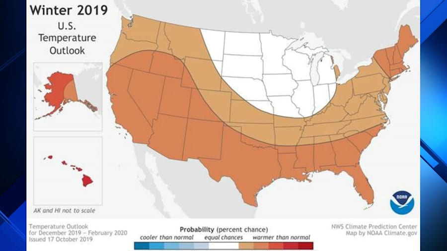
So let’s now look at the NOAA temperature outlook. They say that “the greatest likelihood for warmer-than-normal conditions are in Alaska and Hawaii, with more modest probabilities for above-average temperatures spanning large parts of the remaining lower 48 from the West across the South and up the eastern seaboard. The Northern Plains, Upper Mississippi Valley, and the western Great Lakes have equal chances for below-, near- or above-average temperatures. No part of the U.S. is favored to have below-average temperatures this winter.”

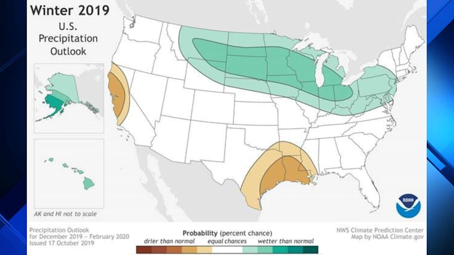
Now let’s see what NOAA projects for winter precipitation: “Wetter-than-average conditions are most likely in Alaska and Hawaii this winter, along with portions of the Northern Plains, Upper Mississippi Valley, the Great Lakes and parts of the Mid-Atlantic and Northeast. Drier-than-average conditions are most likely for Louisiana, parts of Texas, Mississippi, Arkansas and Oklahoma as well areas of northern and central California. The remainder of the U.S. falls into the category of equal chances for below, near, or above-average precipitation.”

Notice the orientation of that above normal stripe of projected precipitation extending east-southeast from Montana across our area and into Pennsylvania. Does that track look familiar? To me, that looks a lot like an Alberta Clipper track. If this is our predominant storm track this winter, then we’ll have fewer chances at those mega-storms that come at us from Texas with 6-to-10 inches of snow, and more of those fast-moving clippers that drop 2-to-6inches of snow. It’ll be interesting to see how the storm track develops!
Something else to remember is that, even though NOAA does not project any areas of below normal temperatures, this does not mean that periodic arctic blasts can’t happen. It just means that, when you average the three months of temperatures from December through February, the overall average will be above normal in most areas. For example, a hypothetical warm December, bitter cold January that really makes you sit up and take notice, and warm February, would average above normal for overall temperatures, even though there was a harsh stretch of winter weather that you’d never forget. The bottom line is to remember that this outlook is a three-month average.
I’ll update you again next month. We’ll see if this outlook holds up!


