

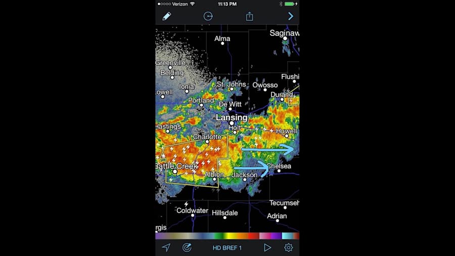
That certainly was a wild area of storms that came through Monday night, and if you looked at a standard radar image at just about any time last night, you just one huge mass of intense rain over large parts of our area.
Recommended Videos
So how do we know what's a "regular" storm, what's a severe storm, which severe storms are rotating, and which of those rotating storms have destructive tornadoes? That's the Doppler part of the updated radars we meteorologists use.
The first thing you need to know is that the radar sends out its beam (a radio wave) at a certain frequency. The radar knows what that frequency is, and how fast the beam is traveling. The second thing you need to know is that wind inside a storm is blowing raindrops around, and those raindrops are targets for the radar beam to hit. When the beam hits raindrops blowing toward the radar, the part of the beam that's reflected back to the radar accelerates and is squished a little bit…it has a higher frequency. The beam that hits raindrops blowing away from the radar that's reflected back to the radar decelerates and is stretched a little bit…it has a lower frequency. The radar calculates the frequency shifts, and shows us where and how fast the wind blowing toward and away from the radar is. When we see a very strong area of wind blowing toward the radar right next to a very strong area of wind blowing away from the radar, we are seeing rotation. The Doppler Radar velocity image below shows what I was seeing in the storm approaching Manchester last night, and remember that there was NO tornado warning yet:
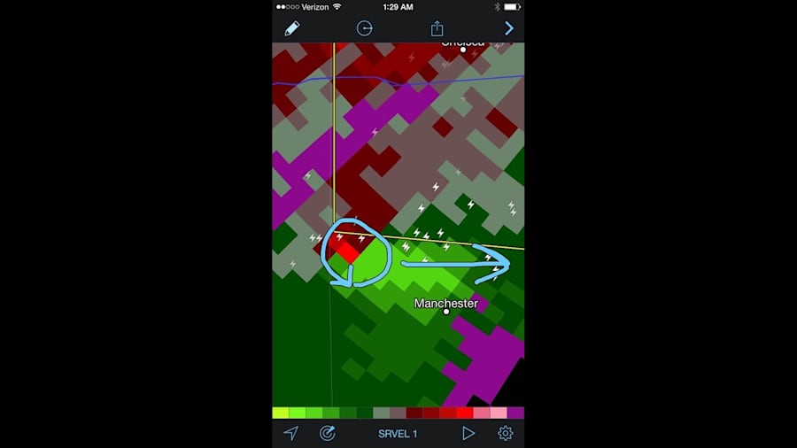
Notice the bright green next to the bright red. The green shows wind blowing toward the National Weather Service radar (toward the upper right), and the bright red shows wind blowing away from the radar. Since I was watching this area (what we meteorologists call a "couplet") tightening, my message with the tweet accompanying this image was: "Manchester…circulation is tightening. No tornado warning, but tornado now possible with the storm. Stay alert." Remember that we had no confirmation of any funnel cloud or tornado at this point. Ben Bailey was seeing the same thing in his live coverage on the air last night, and he conveyed the same concerns.
The relatively new Dual Polarization technology in the Doppler radars has a product called Correlation Coefficient, which shows us the type of target that the radar is seeing. Briefly, the older technology Doppler radars only sent out horizontally oriented pulses. The Dual Pol radars send out both horizontal and vertical pulses, as you see below.
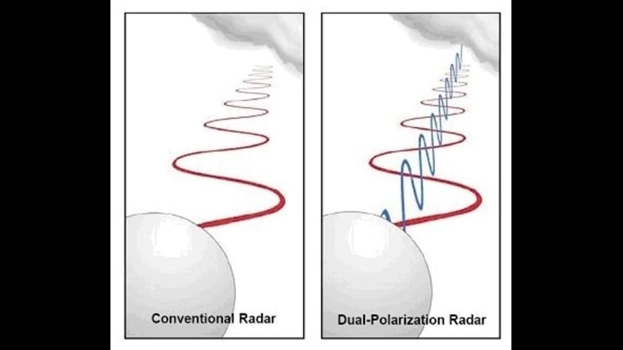
This allows us to, for example, differentiate rain from snow, and rain from hail. And it also allows us to differentiate rain and hail from debris in the air. This next image from last night frightened me when I saw it:
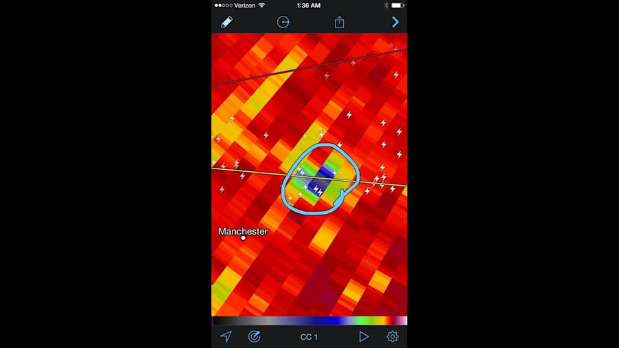
The area of blue I circled indicated a much lower value of Correlation Coefficient and, thus, the great likelihood that I was seeing debris in the air. Thus, even though I had no confirmation that there had been a tornado yet, the radar was identifying a likely tornado on the ground. My tweeted message that accompanied this image was: "This radar product is showing possible tornado debris in the air. TAKE COVER NOW BETWEEN MANCHESTER AND SALINE." Ben noticed the exact same thing in the studio, and showed you this live on the air as it was happening.
The National Weather Service just finished its damage survey for this particular storm, and has confirmed an EF-1 tornado (peak wind 100 mph) that touched down three miles north of Manchester, and ended 5.2 miles northeast of Manchester. The twister damaged roofing and siding of homes, swept one garage from its foundation, and caused a lot of tree damage. There is no question that parts of trees and buildings were swept high in the air, giving the radar an opportunity to identify the non-meteorological targets and, thus, giving us an opportunity to tell you about a tornado when we had no visual confirmation.
So this is how we use our Dual Pol Doppler radar in the most extreme of circumstances. But there are two final things you need to know:
First, this is an ideal example of the radar identifying a strong tornado at night when nobody could see it visually. Brief, weak tornadoes generally have such small circulations that we don't see what I showed you above on the radar. So we sometimes cannot warn you about a small, weak tornado ahead of time. In fact, these tornadoes are generally so brief that they touch down and lift back up before we even have time to issue a warning. Given that these tornadoes cause much less damage and very few casualties, we'll just have to live with this limitation.
Second, the radar shows us developing circulations in potentially tornadic severe storms, but not every storm with tight rotation drops a tornado. Sometimes a funnel cloud develops, but doesn't reach the ground. And sometimes, there isn't even a funnel cloud…the circulation is aloft. But the National Weather Service MUST issue a tornado warning for every storm that presents tornadic tendencies. Given the choice of no warning at all, or advance notice about strong tornadoes with the acceptance that some tornado warned storms won't produce tornadoes, I think most of us would choose the latter.

