We are finally getting some much needed rain across Southeastern Michigan, and while we are cooling things off over the next few days, some of the longer range forecasts are showing that we would warm back up again heading into the middle/end of the month of June.
Here’s the latest longer range forecasts from the Climate Prediction Center:
6-10 Day Temperature Outlook - June 17th-June 21st, 2023:

- Below average temperatures for the Northeastern United States from West Virginia and Eastern Ohio all the way up into Maine
- Below average temperatures for the Western 1/3rd of the United States from Colorado and Wyoming and points west with significantly below average temperatures for parts of the four corners region
- Above average temperatures for the Central United States, all the way down to the Southern United States, with well above average temperatures anticipated for Texas and part of the Gulf Coast
- For Michigan, as of right now we are in equal chances for near normal temperatures
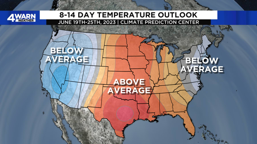
8-14 Day Temperature Outlook - June 19th-June 25th, 2023:

- Below average temperatures forecast to continue for the Eastern Seaboard from North Carolina all the way up to Maine
- Below average temperatures forecast to continue for the Western 1/3rd of the United States from the Front Range all the way to the Pacific Coastline, with well below average temperatures forecast for Four Corners region
- Above average temperatures forecast for the Central United States from the United States/Canadian border all the way down into Texas, and including Gulf Coastline, into the Ohio Valley
- For Michigan, as of right now we are forecast to head into the above average temperature territory by the middle to latter portions of June
Looking at these maps, and some of the longer range data, how these areas are shaping up, this would lend my initial forecasting to think that there may be some sort of blocking pattern forecast to set up again, like we saw over the last few weeks that has kept us on the dry side of the forecast.
The other long range type of forecast we have from the Climate Prediction Center is precipitation. As of right now, these maps for Southeastern Michigan are not much to talk about. Both the 6-10 day precipitation outlook and the 8-14 day temperature outlook keep the chances for near normal precipitation over Metro Detroit, then keep the above average chances for precipitation over the Western United States and then down in the Tennessee Valley and Carolinas, with below average chances for precipitation along the Texas Gulf Coast and in Northern Michigan and the Upper Peninsula.
Of course, we’ll continue to track these forecast as we work through the next 1 to 2 weeks!


