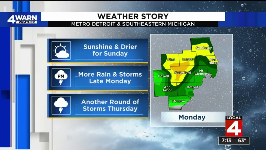
4Warn Weather – The 4Warn Weather Team is tracking Metro Detroit’s next risk for excessive rainfall and thunderstorms.
The rest of Sunday should remain dry, but showers and thunderstorms are expected to roll in Monday afternoon through Tuesday morning.
The Weather Prediction Center has placed a good portion of lower Michigan under a slight risk for excessive rainfall. That means when we see those showers they could cause some flooding concerns late Monday into early Tuesday.
Showers and thunderstorms are expected to roll in on Monday afternoon around 1 p.m. Then, at 1 a.m. on Tuesday, thunderstorms with heavy rainfall are possible as a low-pressure system moves across the state.
Rain returns to the forecast at 3 p.m. on Tuesday afternoon before we get another bit of dry weather. The next chance for showers and thunderstorms returns on Thursday.
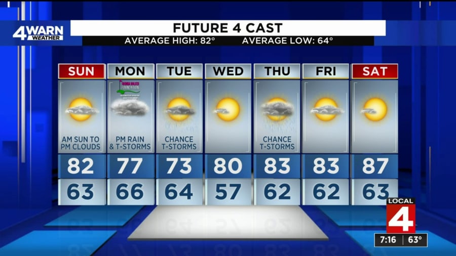
Sunday
On Sunday, high pressure builds back into the forecast, meaning a tranquil day with plenty of sunshine to start the day.
We should see a mixture of sunshine and clouds for much of the afternoon and into the evening. High temperatures head back into the lower 80s on Sunday afternoon.
Sunset is at 8:36 p.m.
Monday
You should expect widespread showers and thunderstorms for much of the afternoon and evening on Monday. High temperatures remain cooler, into the upper 70s.
As of right now, it looks like we get a good slug of moisture overnight Monday and into Tuesday morning, with a widespread 1 to 2 inches of rain possible.
We will need to be on the lookout for some minor flooding issues in poor drainage areas, but widespread flooding is not expected.
Tuesday
We will hold onto a few rain showers and thunderstorms on Tuesday as the front rolls through.
Otherwise we will see some sunshine and clouds throughout the day as high pressure moves into the region behind the front.
Temperatures remain below average into the 70s through Tuesday.
Wednesday
Wednesday should stay dry as high pressure builds back into the region.
That means plenty of sunshine for the middle of the week. High temperatures heading back into the 80s by the afternoon.
Thursday
Another low-pressure system moves through the region coming out of Canada on Thursday, and that brings us another chance of showers and thunderstorms.
High temperatures warming back into the lower 80s by Thursday afternoon.
Rest of week
Drier weather builds in the forecast just in time for the Woodward Dream Cruise next weekend up in Oakland County.
A mixture of sunshine and clouds will give way to plenty of sunshine by the start of next weekend. High temperatures remain in the 80s both Friday and Saturday.
That comes with a warming trend as well. High temperatures making it into the upper 80s by Saturday afternoon.
>>>> Find the latest forecast from the 4Warn Weather team here <<<<
Download the WDIV 4Warn Weather app in the Apple app store or the Google Play store.