

4Warn Weather – It’s a cool, but pleasant Labor Day.
A high-pressure system is making sure that Southeast Michigan gets ample sunshine for the first half of the week.
Monday’s high was only 72 degrees at Detroit Metro Airport, while the average high for Sept. 2 is 79 degrees. Just last week, it was 91 degrees on Friday, Aug. 30. It reached 95 degrees on Tuesday, Aug. 27, which tied with June 17 for the hottest temperatures this year.
Monday Night
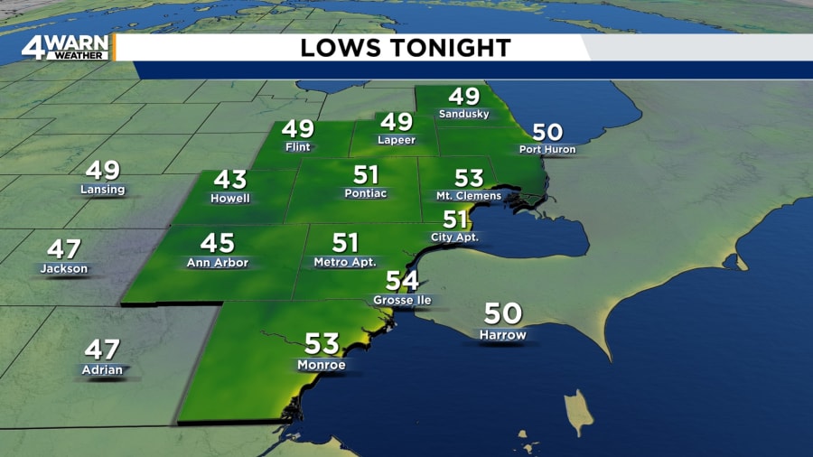
After grilling or attending a cookout, you might want to sit around a bonfire on Monday night. Under mostly clear skies, it will be chilly. Lows will be in the lower to mid 40s near Ann Arbor and Howell, upper 40s in the Thumb, and around 50 degrees in Westland, Livonia, Southfield, Detroit, and Sterling Heights.
Tuesday
That also means it will be a cool start to Tuesday. Most people will want to wear a jacket for school and work in the morning. It will be a comfortable and dry day. Under mostly sunny skies, afternoon temperatures will reach the mid 70s. Winds will be out of the east-southeast around 5 mph.
Tuesday night will be mostly clear as temperatures fall to the lower 50s.
Wednesday
The sunshine will stay for Wednesday and the normal temperatures will make a comeback. Highs will be around 80 degrees. It will be mostly clear at night with lows in the upper 50s to 60 degrees.
Thursday
Summer wants to reintroduce itself on Thursday. A few clouds will begin developing as a cold front nears from the west. Highs will be in the mid 80s. Lows will be in the lower to mid 60s.
Friday
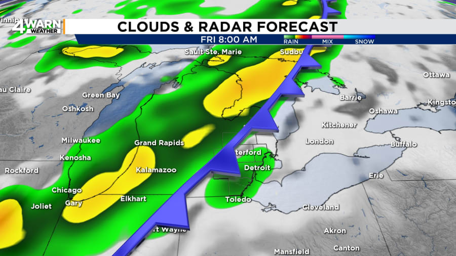
Showers and thunderstorms will arrive in Southeast Michigan by Friday morning with the approaching cold front. The chance of showers will last through the day and night. While the humidity will be slightly higher, temperatures will be lower. Highs will be in the mid to upper 70s.
Saturday
A few showers will be possible on Saturday in Southeast Michigan. Michigan fans may want to take ponchos or rain jackets to the Big House as the Wolverines take on the Texas Longhorns. Highs will be sharply cooler in the mid to upper 60s. Lows will be in the mid to upper 40s.
Sunday
Are you planning to tailgate for the Detroit Lions regular season opener on Sunday. The forecast calls for dry, but similarly cool temperatures.
Although Metro Detroit is getting a stretch of dry weather until the end of the week, a few neighborhoods are still feeling the effects of last week’s rain. A flood warning continues for the Huron River near Hamburg in Livingston County. Minor flooding was occurring Monday, and it is forecast to continue until early Friday.
Find the latest forecast from the 4Warn Weather team here
Remember to download the free 4Warn weather app -- it’s easily one of the best in the nation. Just search your app store under WDIV and it’s right there available for both iPhones and Androids! Or click the appropriate link below.


