

4Warn Weather – Brace for the cold and snow.
Following an early morning low of 8 degrees at Metro Airport, Wednesday afternoon’s temperatures managed to reach the mid-20s. The wind chills continue to be noticeably lower.
Wednesday night, clouds will increase as a clipper system approaches from the west with light snow. Overnight lows will range from 8 to 14 degrees. Southwesterly winds of 5 to 15 mph will contribute toward wind chills of several degrees below zero.

Thursday
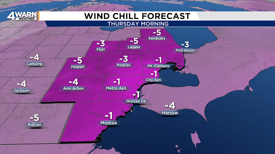
The snow will begin after midnight and last through Thursday morning. This means the morning commute will be cold and snowy, with the possibility of slick roads. Snow showers will taper off by the early afternoon.
Widespread accumulations will be around one inch, but a few locations could pick up close to two inches.
Highs will be around 30 degrees, but it will feel no warmer than 20 degrees. Winds will be out of the southwest at 5 to 15 mph.

Thursday night will be partly to mostly cloudy, with lows in the lower 20s in Metro Detroit and teens in the Thumb.
Friday
Friday will be a better day for outdoor activities. It will be mostly cloudy and breezy. Highs will be in the lower to mid-30s, but wind chills will be in the teens and lower 20s.
Friday night’s temperatures will range from 25 to 30 degrees. Skies will be mostly cloudy, but rain and snow will arrive overnight.
Saturday
A wintry mix will be possible for Saturday, particularly for the first half of the day. Conditions are expected to improve in time for the evening kickoff of the Detroit Lions vs. Commanders game, but morning and afternoon tailgaters should be prepared for the wintry weather. After highs in the lower to mid-30s, evening temperatures will be in the 20s.
Sunday
The arctic air will return to Southeast Michigan with a vengeance and deliver the coldest air that we have seen this winter.
Overnight temperatures into early Sunday morning will be in the teens. A few lake-effect snow showers will try to travel into Southeast Michigan from Lake Michigan. Highs will be in the teens to 20 degrees. Sunday night’s lows will be around 0 degrees.
Martin Luther King Jr. Day
It will be a bitterly cold Martin Luther King Jr. Day. Monday’s highs will only be around 10 degrees, with lows of -5 to 0. That is not even taking into account the wind chill.
Wind chills from Monday night into Tuesday morning could plummet to -20 degrees (or 20 degrees below zero). Dangerously low wind chills near -25 degrees can result in frostbite in 15 minutes.
Tuesday
Tuesday’s highs will only be in the single digits, with the lows below zero in most of Southeast Michigan. Metro Detroit’s official record low for the date will not be threatened. The thermometer measured -21 degrees on Jan. 21, 1984.
Tuesday’s temperatures will be well below the average high of 32 degrees and the average low of 18 degrees.
Temperatures will climb late in the week and return to the 20s.
Remember to download the FREE Local4Casters weather app -- it’s easily one of the best in the nation. Just search your app store under WDIV, and it’s right there, available for both iPhones and Androids! Or click the appropriate link below.
- Download for Android mid-20s
