

Mid-February is bringing the snow.
From the afternoon of Wednesday, Feb. 12 through early Thursday, Feb. 13, most of Metro Detroit picked up a fluffy 3 to 6 inches. Lenawee and Monroe counties, which saw a wintry mix, picked up 2 inches or less. Parts of the Thumb received as much as 10 inches. This snowfall was the result of a low-pressure system that traveled across northwest Ohio and Upstate New York.
List of Metro Detroit snow totals by city after Wednesday’s winter storm
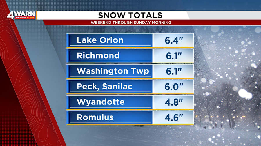
The weekend of Feb. 15-16 delivered another 3 to 6 inches in much of Metro Detroit by Sunday morning. Just 2.3 inches was the tally measured in Ann Arbor, while 6.4 inches fell in Lake Orion. Lake-effect snow produced up to another inch during the afternoon and evening.
This is how much snow accumulated in your community or a community near you from late Friday night through Sunday morning:
Genesee County
- Goodrich – 4.5 inches
- Flint – 3.7 inches
Lapeer County
- [No official snowfall reports]
Lenawee County
- Morenci – 2.3 inches
Livingston County
- Howell – 3.5 inches
Macomb County
- Richmond – 6.1 inches
- Washington Township – 6.1 inches
- Macomb Township – 4 inches
- Eastpointe – 3.5 inches
Monroe County
- [No official snowfall reports]
Oakland County
- Lake Orion – 6.4 inches
- White Lake – 4.5 inches
- Wolverine Lake – 4.5 inches
- Berkley – 3.5 inches
Sanilac County
- Peck – 6 inches
- Lexington – 4 inches
St. Clair County
- Port Huron – 4 inches
Washtenaw County
- Chelsea – 3.9 inches
- Saline – 3.2 inches
- Ann Arbor – 2.3 inches
Wayne County
- Wyandotte – 4.8 inches
- Romulus – 4.6 inches
- Detroit – 3.2 inches
- Livonia – 3.2 inches
- Grosse Pointe Farms – 3 inches
While this brings the snowfall for some Southeast Michigan communities to more than a foot in a matter of a few days, were you expecting more snow from the weekend “winter storm?”
Some places received what was forecast, while the snowfall in other spots fell short.
What happened?
The short answer:
The forecast is based on probabilities, and the more likely scenario had a wrench thrown into plans. Some of the moisture that would have led to more snowfall in Metro Detroit was snatched up and used over other regions. The weather system was also nudged off course.
Here is an analogy:
If your regular commute to work does not have interference from weather or unexpected congestion, your drive should take roughly about the same time each day. However, imagine being delayed at a train crossing. You finally reach the freeway and discover that traffic is backed up for some reason. You decide to take the street. Things are not going as planned. You arrive to work late, and your day is thrown off track.
The long answer:
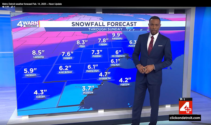
While Friday gave us a break in the snowy weather for Valentine’s Day plans, another round of snow and wintry mix was expected Saturday morning. Friday’s forecast for the weekend called for 4 to 6 inches of snow, and localized spots of 7 inches, for most of Metro Detroit from Saturday to Sunday afternoon.
The first wave of the weekend’s snow brought 1 to 3 inches to Metro Detroit on Saturday morning. Afternoon temperatures above freezing led to some limited melting.
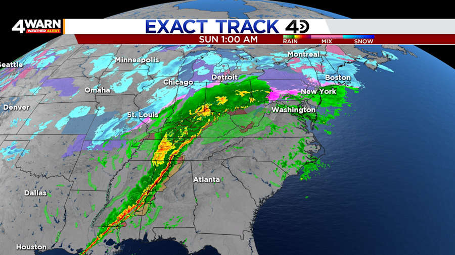
Saturday afternoon gave much of Southeast Michigan another break in the action, but a low-pressure system near Missouri and Illinois was strengthening. The system was projected to move toward the Ohio Valley, fuel itself with moisture or energy flowing northward from the Gulf, and transport that moisture to the Great Lakes region on Sunday.
As confidence grew that part of Southeast Michigan would get significant snowfall for Sunday’s round of snow, the National Weather Service upgraded the Winter Storm Watch to Winter Weather Advisories and Winter Storm Warnings. (The Winter Storm Warnings would be canceled and replaced with Winter Weather Advisories early Sunday morning.)
The projected additional accumulations were boosted for the region’s easternmost counties to 5 to 7 inches. This accounted for the potential of heavier snow closer to the center of the system and the chance of moisture from Lake Huron contributing to the snowfall due to northerly and northeasterly winds. Most communities west of I-275 were looking to receive an additional 3 to 5 inches.
Late Saturday night, another situation was unfolding hundreds of miles from Metro Detroit. Powerful storms were flaring up over the Tennessee Valley and other parts of the Southeast.
These ravenous and destructive storms consumed the moist and milder air, and they left behind drier air on the cold and snowy side of the low-pressure system. This process also pushed the system farther east.
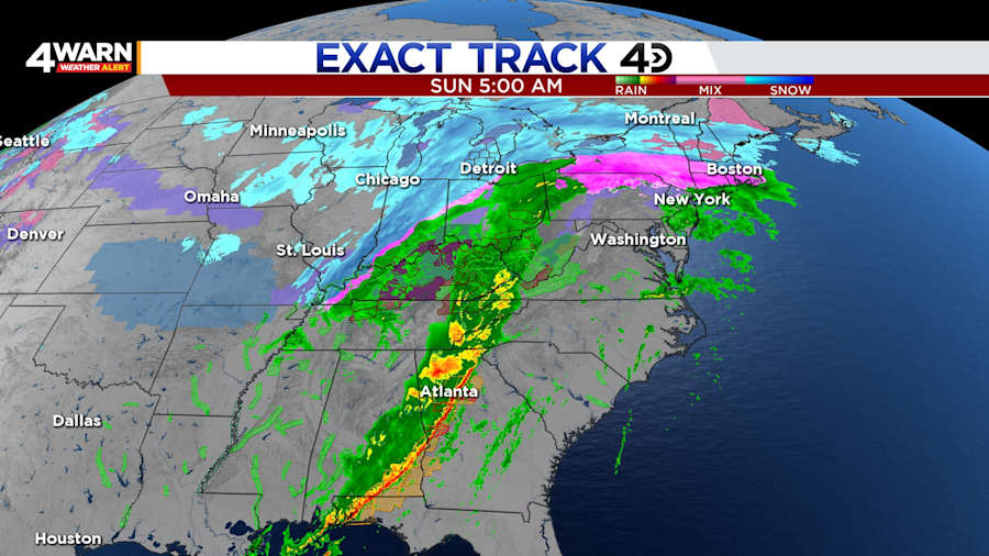
This disruption came at a cost. Instead of distributing that moisture over a much larger area, the system dumped heavy rain that led to deadly flooding in Kentucky.
Over the span of 48 hours, many communities in Kentucky received 6 inches or more of rain. Over the weekend, the liquid in Metro Detroit’s snow was equivalent to about a half inch of rain.
Floods also ravaged communities in Tennessee, West Virginia, Virginia and North Carolina. Damaging winds and tornadoes swept across the Southeast.
Southeast Michigan had a loss of potential snow. The losses in the South were very different.


