

4Warn Weather – Summer officially arrives this week, and the heat is picking up to welcome it.
Temperatures reached the lower 80s on Monday afternoon, and it was expected to stay mild overnight.
Under partly cloudy skies, lows will range from 60 to 65 degrees. The cooler temps will be found in Lapeer, Sandusky, and Ann Arbor. Lows will be near 65 degrees in Detroit, Allen Park, and Roseville.
Tuesday
Tuesday will bring an uptick in heat and humidity. Metro Detroit’s temperatures will quickly rise into the 70s in the morning and to around 80 degrees by noon.
Expect highs in the upper-80s later in the afternoon. The increased moisture will make the air feel sticky.
A couple of pop-up showers or thunderstorms will also be possible, especially in the evening. Otherwise, there will be a mix of sunshine and clouds.
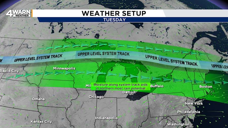
With partly cloudy skies, a couple of showers could last into Tuesday night. Temperatures will be in the upper 60s to 70 degrees.
Wednesday
Wednesday is expected to be hot and potentially stormy. With highs in the mid-80s, the heat and moisture could fuel storms along and ahead of an approaching cold front.
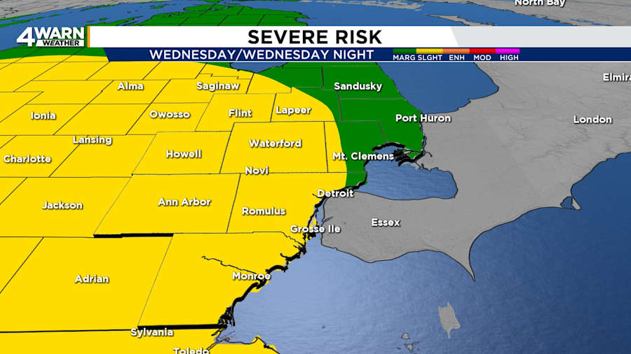
All of Southeast Michigan is under a risk of severe weather, including a “slight” or level 2 of 5 risk for most of the region.
Severe storms could bring the threat of damaging winds, heavy rain, and hail.
The expected timeframe will be narrowed, but it appears that the active weather will be in the evening or overnight hours.
Wednesday night’s lows will be in the mid-60s.
Thursday
Behind the cold front, temperatures will return to average levels on Juneteenth. Apart from lingering showers in the morning, skies will give way to sunshine by the afternoon.
Thursday’s highs will be in the upper 70s to lower 80s. Lows will be around 60 degrees.
Friday
Friday’s weather is expected to be similar to Thursday’s conditions, with the added benefit of being dry all day. Sunshine will help temperatures reach the lower to mid-80s on the final day of spring.
Summertime
Summer will arrive before the night is over. The summer solstice will occur at 10:41 p.m. It will be partly cloudy, with lows in the mid-60s.
Weekend
Temperatures are expected to rise over the weekend. Highs will be in the mid-80s on Saturday and around 90 degrees on Sunday.
This would be Metro Detroit’s first 90-degree day of the year. The weekend is expected to be mainly dry, although a few showers are possible on Saturday.
Monday
Then, the heat turns up a notch. Next Monday’s scorching weather could push temperatures into the mid-90s.
Anyone heading to Downtown Detroit or Downtown Windsor for the Ford Fireworks will want to wear light-colored and breathable clothing. Staying hydrated will be essential.
Monday’s record high is 95 degrees.
Did you catch a dramatic sky or unusual weather? Share your photos with Local 4 on MIPics.
Find the latest forecast from the 4Warn Weather team here
Remember to download the free 4Warn weather app -- it’s easily one of the best in the nation. Just search your app store under WDIV, and it’s right there, available for both iPhones and Androids! Or click the appropriate link below.
