DETROIT – Scattered showers and thunderstorms this afternoon will continue to diminish in both coverage and intensity and, by this evening, any activity left in the area should fizzle out pretty quick, leaving us quiet for the rest of the night.
Clouds will be stubborn to move out initially, but then start breaking up. Lows should bottom out generally in the mid 60s (18 degrees Celsius), with west to northwest winds at 5 to 10 mph. This will be your “best” sleeping night weather for at least the next week if you don’t have air conditioning.
Recommended Videos
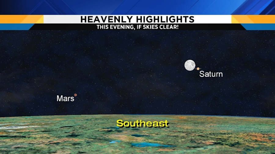
If skies manage to clear out at all this evening, take a look at the southeastern sky, where you’ll see a beautiful Heavenly Highlight. It’ll be easy to find the Strawberry Moon, as June’s full moon is called, and right next to it will be the brilliant planet Saturn! As an added bonus, if you have a clear view of the southeastern horizon, you’ll also see Mars to the lower left of the moon and Saturn.

Even if some of us start our Thursday with partly cloudy skies, we’ll end up mostly sunny for the balance of the day. Highs should easily reach the mid to upper 80s (31 degrees Celsius). Northwest wind will shift to the southwest at 4 to 8 mph.
Thursday’s sunrise is at 5:59 a.m., and Thursday’s sunset is at 9:14 p.m.
Partly cloudy Thursday evening, then becoming mostly clear overnight. Lows in the upper 60s (20 degrees Celsius).
Here comes the heat wave
Mostly sunny on Friday, with highs in the low 90s (33 degrees Celsius). The humidity will make it feel like the mid 90s (36 degrees Celsius).
Warm and oppressive Friday night, with lows in the mid 70s (24 degrees Celsius).
Mostly sunny, very hot and humid on Saturday -- this will be the hottest day of the heat wave. Highs should easily reach the mid to upper 90s (36 degrees Celsius), with heat indices of 107 degrees (42 degrees Celsius).
Warm and oppressive Saturday night, with lows in the mid 70s (25 degrees Celsius).
Partly cloudy on Sunday with some thunderstorms possible during the afternoon as a weak cold front approaches. As long as we get the storms, highs should be capped at the low 90s (33 degrees Celsius), and heat indices near 100 degrees (38 degrees Celsius). However, should the front slow down or the storms not materialize, then we’ll get even warmer.
Becoming partly cloudy Sunday night, with lows in the low 70s (22 degrees Celsius).
Next Monday through Friday look dry right now, and continued hot. Highs will range from the upper 80s (31 degrees Celsius) on Monday and Tuesday, to the low to mid 90s (33 to 34 degrees Celsius) by Friday. Overnight lows look to remain very uncomfortable -- generally 70 to 73 degrees (21 to 22 degrees Celsius).
As we’ve been telling you all week, now it the time to prepare for this heat. Those without air conditioning, especially the elderly, those in poor health, and very young children, are particularly susceptible. Try to make plans with family and friends that do have air conditioning to perhaps visit with them to take some of the heat stress off your body.
Remember that this is much more than about the daytime highs: overnight lows being so warm don’t allow your body to cool down much, so you remain stressed through the night, which further taxes your system. If you don’t have access to air conditioning, do whatever you can to cool your core body temperature, and also stay well hydrated with water (remember that alcohol and caffeine dehydrate you).
Cold showers and baths work wonders to cool you off -- please consider that, and also please check on your elderly neighbors and neighbors with children. Remember that you can also head to the air conditioned mall and do a little shopping to escape the heat.
Also remember that this heat is dangerous for our pets, too. They need access to cool, fresh water to stay hydrated, and remember if you take your dog for a walk that the pavement will be very hot during the day, and can burn the bottoms of their feet.
Finally, you’ve undoubtedly seen the news stories this summer about children dying when left in hot cars. You need to understand that a car in the sun will heat up 20 degrees (about 10 degrees Celsius) just in the first 10 minutes, and then another 10 degrees (about five degrees Celsius) in the following twenty minutes. So, let’s keep the math simple and consider the following:
A car left outside with an initial interior temperature of 70 degrees (21 degrees Celsius) because you had the air conditioning on when you parked:
- In 10 minutes, it’s 90 degrees (32 degrees Celsius) in your car.
- In 30 minutes, it’s 100 degrees (38 degrees Celsius) in your car.
That’s why you can’t leave your young children or pets in the car, even just for ten minutes, in this heat.

