DETROIT – A Winter Storm Warning continues through the evening north of 8 Mile Road, with a Winter Weather Advisory south of 8 Mile Road.
Those of you in the Warning area will see mostly or all snow this afternoon, and the intensity will increase noticeably; the drive home from work later this afternoon will likely be a challenge. Things are a little different in the Advisory area, where rain, sleet, and freezing rain are also likely, with an eventual changeover to snow -- you’ll also have a rough drive home from work later.
Recommended Videos
SE Michigan has turned completely to snow. pic.twitter.com/sB7Hh9aK9l
— WDIV Local4Casters (@Local4Casters) March 1, 2016
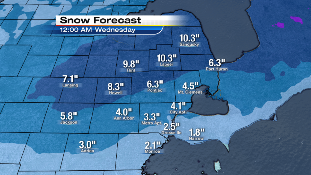
Snow totals, as I explained with last week’s storm, are always a challenge when you have ice or rain mixing in. But based upon everything I’m seeing, here are my general thoughts on how the snow accumulations will play out -- and keep in mind that this is TOTAL snow received today and tonight, which includes snow that we’ve already received.
As you can see, the gradient increases from southeast to northwest -- in-other-words, from the areas that get the most rain and/or ice, to the areas that get all snow. All precipitation will end from west to east between midnight and 2:00 a.m., so the road crews should have plenty of time to get the main roads cleared by Wednesday morning.
Neighborhood streets are always the last to get plowed, so most superintendents’ decisions on a snow day tomorrow will be based on those roads, and not the main roads. Wind will blow from the northwest at 15 to 25 mph, so there could be some blowing and drifting -- especially in the colder, northern areas where the snow won’t be as "wet." Lows will drop into the upper teens (-8° Celsius across the river for our Canadian friends).
Partly cloudy on Wednesday, with highs in the mid-to-upper 20s (-3° Celsius). West wind at 10 to 15 mph. Wednesday’s sunrise is at 7:06 a.m., and Wednesday’s sunset is at 6:25 p.m.
Increasing clouds Wednesday night, with lows in the upper teens (-8° Celsius).
We have a chance of light snow on Thursday, but accumulations (if any) will be light. Highs in the upper 20s (-2° Celsius).
Snow ends Thursday evening, with overnight lows in the mid teens (-9° Celsius).
Mostly sunny on Friday -- a bright end to the work week -- with highs near 30° (-1° Celsius).
We have another chance of light snow on Saturday, with highs in the mid 30s (2° Celsius).
Partly cloudy and warmer on Sunday, with highs near 40° (4° Celsius).
Then get ready for another big-time warm-up, with highs Monday, Tuesday and Wednesday in the 50s, although rain chances start creeping in Tuesday, and ramp up on Wednesday. It’ll become breezy, too (as it usually does with big wintertime warm-ups).
